High in the Himalayas, above the wrecked road and settlements that follow the Bhote Koshi towards the plains of Nepal, another lake is forming.
It did not exist before Wednesday. It has been created from the wreckage of the catastrophe itself: glacier ice, boulders, moraine and earth torn from the mountains and deposited across the upper river, where they have formed an accidental dam. Behind that barrier, water is accumulating again.
For the communities below, this may now be the most immediate danger. The first natural dam broke. The catastrophe has built another one.
A Lake Where There Was No Lake
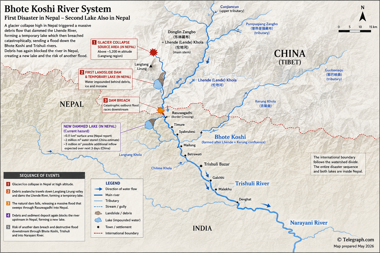
Nepalese disaster officials examining satellite imagery say the newly impounded water covers about 0.11 square kilometres roughly 18 kilometres upstream of Rasuwagadhi, the principal border crossing between Nepal and Tibet. Chinese authorities, observing the same mountain system from the other side of the frontier, estimated that about two million cubic metres of water had accumulated behind the blockage by Thursday morning.
More water is entering the system. China’s Ministry of Water Resources has warned that rainfall could bring several million cubic metres of additional inflow into the watershed over three days. Hydrological teams have been sent into the Gyirong area, emergency monitoring has been intensified and officials have warned that the natural barrier could fail.
Nepal has issued warnings of its own. People living or working close to the Bhote Koshi have been told to remain away from the river, while rescuers searching through the wreckage of the first flood must now work beneath the possibility of another.
There is nothing engineered about the structure holding the water back. It is a wall assembled by violence: fresh rock, glacier ice, shattered soil and sediment dumped into a mountain river. Water can escape gradually through such a barrier, or cut a channel across it. But it can also penetrate the debris, undermine it and suddenly tear it apart. What matters is not merely the size of the lake, but how rapidly its water would be released if the dam failed.
How the First Disaster Began
The events of Wednesday were initially difficult to understand. There had not been the kind of exceptional rainfall that would ordinarily explain such a flood. Nepalese reports considered the possibility of a glacial lake outburst, while a seismic signal detected in the region raised questions about whether an earthquake had destabilised the mountainside.
The picture emerging from Chinese satellite analysis and Nepalese investigation is more complicated, and more dramatic. China’s Ministry of Natural Resources says the initiating event was a high-altitude glacier collapse inside Nepal, above 5,200 metres.
The collapse began above a small upper tributary known in Chinese reporting as Cuojiancuo, . The ice plunged down the mountain, gathering moraine, rock and earth as it accelerated. What began as a collapse of glacier ice became an avalanche, then a high-speed debris flow and finally a torrent of mud, boulders and water.
Chinese geologists describe it as a chain disaster. Their reconstruction traces the debris through Cuojiancuo into Guobaxiaqu, and then into Donglin Zangbo. China-Nepal border documents identify Donglin Zangbo with the Lende or Lhende River on the Nepalese side.
The speed was extraordinary. Chinese investigators estimate that the moving mass may have averaged more than 50 metres a second, roughly 180 kilometres an hour. In the steep Himalayan valleys, the mountain itself had become an accelerator.
The First Dam
The avalanche did not merely descend the valley. It altered it.
Ice, rock and sediment obstructed the Lhende and created a temporary reservoir. Water accumulated behind the debris until the barrier could no longer contain it. When it failed, the stored water was released into a river already filled with the material stripped from the mountains above.
The resulting surge struck the Gyirong border area in Tibet and moved through the cross-border river system towards Rasuwagadhi. At the confluence of the Lhende and Kerung Khola, the combined river becomes the Bhote Koshi in Nepal.
From there the flood followed the geography south. It tore through Timure and Syabrubesi, continued past Mailung and Betrawati and entered the Trishuli system. Settlements, roads, bridges and hydropower infrastructure lay directly in its path. The water continued towards Galchhi, Gajuri, Malekhu and Muglin, eventually reaching the Narayani river system.
For people downstream, what appeared to be a flood arriving from Tibet had begun with a glacier collapse inside Nepal. For Chinese investigators, the debris had arrived through the upper mountain channels before striking Gyirong. The apparent contradiction disappears when the watershed is viewed as a whole: the rivers cross and recross a political frontier that has no meaning to water, ice or gravity.
The Mountain Has Built Another Dam
Now the wreckage left behind by that first event has created another obstruction.
Satellite imagery examined by Nepalese authorities shows a new body of impounded water upstream of Rasuwagadhi. Chinese hydrological reporting describes a debris-dammed lake in the same upper disaster zone, near the Cuojiancuo and Purepuqiang Zangbo, system. The nomenclature differs across Chinese and Nepalese maps, but the warning does not: water is being held behind recently deposited natural debris and the stability of that barrier is uncertain.
A second failure would occur in a landscape already transformed by the first. River channels are loaded with fresh sediment. Slopes have been disturbed. Bridges and sections of road have disappeared. Enormous quantities of loose material remain available to be swept up by another surge.
A second flood, therefore, would not necessarily be simply the release of the water visible in the new lake. As it descended, it could gather mud, rocks, trees and debris and increase in volume and destructive power.
Minutes, Not Hours
The most unsettling lesson from the Chinese reconstruction is the speed with which the first disaster developed. If the estimate of more than 50 metres a second is broadly correct, communities in the upper valley may have had only minutes between the beginning of the collapse and the arrival of the debris flow.
That makes the new lake particularly dangerous. Monitoring can identify changes in its size and the condition of the barrier, but once a sudden breach begins, warning time in the narrow upper valleys could be desperately short.
The people most exposed now include not only those who live beside the river but the rescuers, soldiers, police, engineers and families who have returned to its banks to search through the remains of the first flood.
Waiting Above Rasuwagadhi
There is no certainty that the new dam will burst catastrophically. Water may drain gradually, a channel may develop through the debris, or the barrier may remain sufficiently stable for the immediate danger to diminish. The figures being reported by Nepal and China are also preliminary and describe different measurements: Nepal has reported the approximate surface area of the lake, while Chinese authorities have estimated the volume of water impounded.
But the sequence that produced Wednesday’s disaster is no longer theoretical. It has already happened once in this valley.
A glacier collapsed. The falling ice gathered rock and earth. The debris blocked a river. A lake formed behind it. The barrier failed, and the water raced down the mountains through Tibet and Nepal.
Now, above Rasuwagadhi, the river has been obstructed again.
Chinese teams are watching the upper watershed. Nepalese authorities are warning people downstream to stay away from the river. In the narrow Himalayan valley below, communities that have scarcely begun to understand what happened on Wednesday are waiting to discover whether the mountain will release its water slowly, or all at once.